

Hiking in the Aspromonte
The Sentiero dell'Inglese


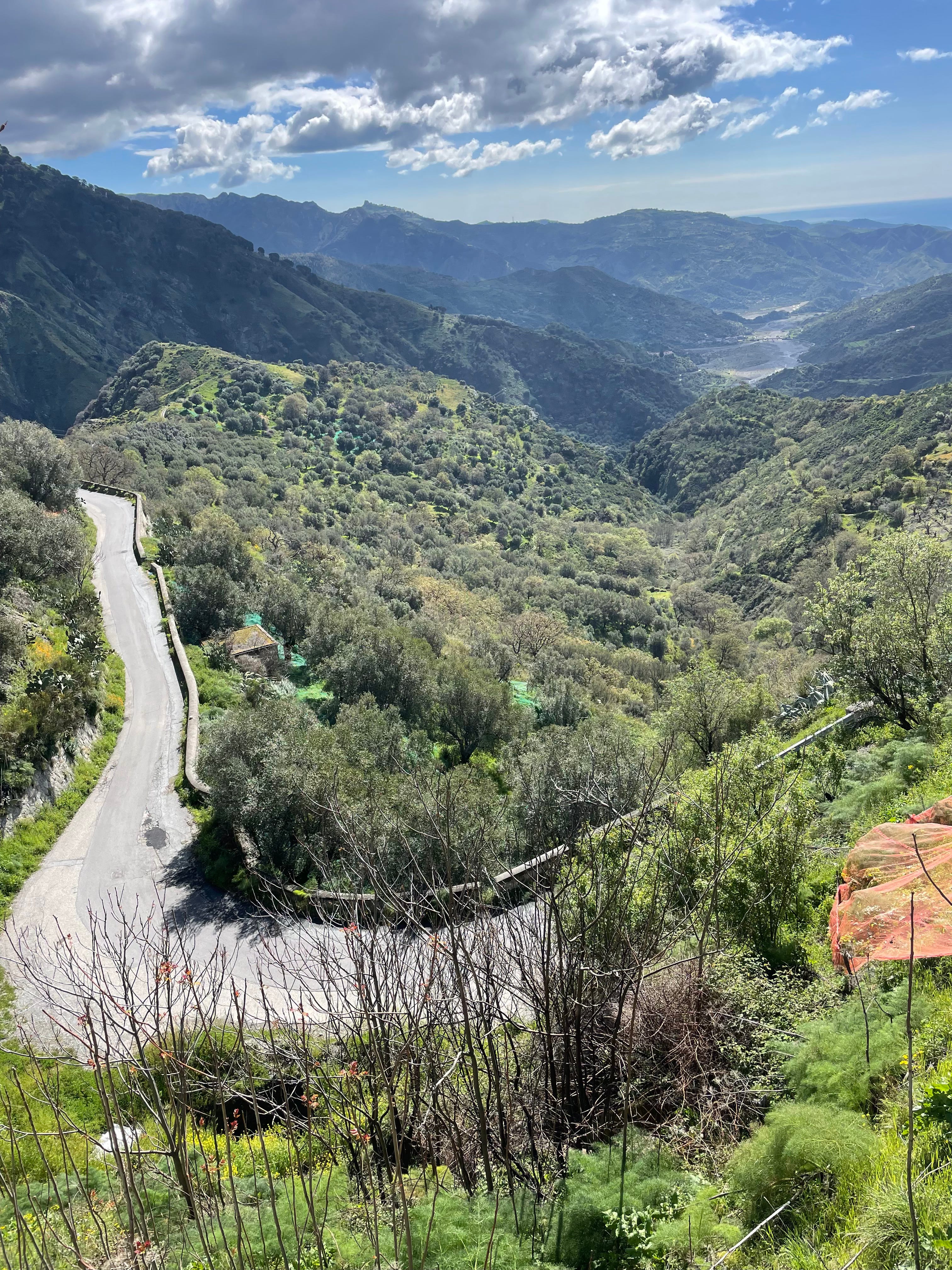
On April 1st Eugénie (my sister) and I set off from Pentedattilo and walked to Staiti along the Sentiero dell'Inglese: six days of hiking and feasting in between towns and villages in the Aspromonte mountains. The trail follows the footsteps of the English nineteenth century author and painter Edward Lear. It was completed in 2019 and is becoming popular with hikers though we had the trail to ourselves. It takes on average six days to complete but can be done in five, and could be spread out beyond six. The highest point is Monte Cerasia at 1013 metres. It's not a particularly difficult route and it's all along well sign-posted footpaths and quiet roads. We agreed it was an ideal first hike – neither of us had hiked for more than a day before.
Location: The Aspromonte mountains in Calabria, southern Italy.
Length: Approximately 80km
Highest point: Monte Cerasia 1013 metres.
Best time of year: It's too hot to do the trail in the summer. In the winter months it isn't possible to cross the riverbeds which means diversions to bridges (which is what we ended up doing).


How it works
The Cooperativa San Leo runs the network of hosts along the route and will send out the GPS tracks to interested hikers. You contact the hosts to book accommodation in each town (see the list of hosts here; you can message in English). The Cooperativa makes sure the hosts check in with them when you arrive, and they organise food. In theory you can camp or you can arrange to hike with a guide. You can also pay to have your belongings moved from town to town. We chose to carry our things and to stay with the network of hosts which meant paying €25 a night per person to stay in really decent accommodation. On top of this, we paid on average €25 a night each for a full evening meal, €5 for a prepared breakfast except in Bova where we ate €1 croissants in one of the bars, and €5 for a packed lunch most days.
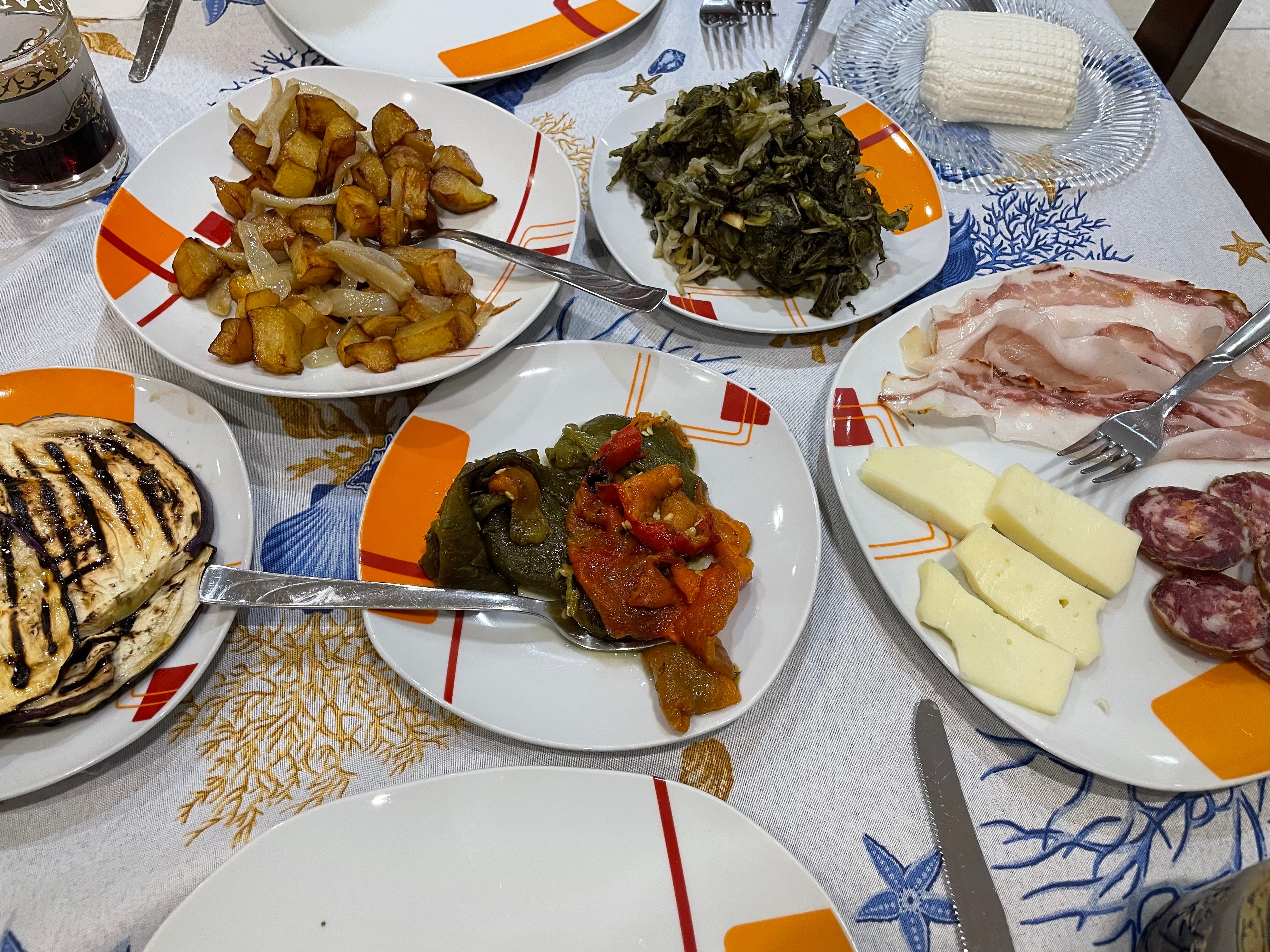
The evening meals are typically an assortment of antipasti (many small plates of local dishes from local cheeses, meats, sautéed vegetables, slow cooked beans, olives etc), followed by a plate of maccheroni (typical pasta from the area, often homemade) with an aubergine and tomato sauce or meat ragu, and then slow cooked meat, vegetables or salad. There's plenty of wine. All the ingredients are either produced by the hosts or local farmers in the area. It's not a problem if you're vegetarian but you need to let them know when you make your food arrangements.
You can read more about local food and farming here.
What we carried and wore
Water (approximately three litres each), packed lunch, warm pyjamas (accommodation is cold), essential toiletries including suncream, first aid kit, a warm top, shorts and spare t-shirt, light trainers for the evenings, kindle and writing book, phone charger, binoculars (my idea...), dog repellent in the form of an electrical device that makes a high frequency noice (it did come in handy).
We wore lightweight hiking trousers/leggings, t-shirts and walking boots most of the time and did make use of light raincoats.


Pentedattilo – Bagaladi. Leg 1.
We strapped ourselves into our bursting backpacks, hugged Rosa goodbye and climbed slowly up and out of Pentedattilo. From then on the iconic monolith that looms so precariously over Pentedattilo would slowly grow smaller behind us, an almost constant marker of our starting point. We set off in unexpected sunshine but soon encountered the biggest challenge of the hike. It had been an unusually wet Spring and the path up our first hill had turned to clay. Every few steps what felt like two kilos of the stuff would cake each walking boot. We slipped, swore, groaned and paused constantly to wipe the worst of it off and I hesitantly promised this wouldn't be a recurring obstacle (it wasn't). Once clay free, we followed a ridge deeper inland with views of Pentedattilo to our left and across two valleys to Bova high up on the right. There were wildflowers everywhere: sulla, calendula, orchids, asphodels and so many more. Wild pear trees were in blossom and we walked through many olive groves, some still with nets lying below the trees. We passed sheep and goats, mountains shaped like pyramids, dried up riverbeds despite the rain, many cassetta—small one-roomed buildings used as barns and refuges during harvests—and only one house that was still inhabited until we approached Bagaladi.


Just outside Bagaladi, a woman called out 'buonasera' ('good evening') from her balcony. Eugénie commented on the huge lemons she had growing in her garden and I asked if they were cedri. A minute later and we were peeling off damp coats, removing muddy boots and taking seats at her table before she brought us coffee and about five different cakes which she insisted we ate. We soon reached our accommodation and explored Bagaladi (known for its olive oil) before gorging ourselves on antipasti cooked by a local in her home.
Confusingly, the word for cedro in English is citron. Cedri are huge citrus fruits with a thick, sweet and edible pith which is delicious finely sliced and added to salads. The cedro's surprisingly small, sour segments taste similar to lemons. The outer skin is intensely aromatic. They are the oldest citrus fruit and play an essential part in the Jewish holiday of Sukkot. It was the Jews who brought cedri to this area 2000 years ago.

Bagaladi – San Lorenzo – Amendolea. Leg 2.
Full sunshine greeted us the following morning and we headed up, up and up to San Lorenzo, an almost completely abandoned town that sits at the top of a hill. We stopped to rest and take in the 360 views. Then we headed down towards the village of San Pantaleone, stepped into a church to see a 13th century icon of the Madonna and Jesus, and stopped to take in a lush hillside called Barone. This was technically a diversion from the trail but the Amendolea river, which we would reach later that day via a bridge, was too full to cross by foot. But Barone ended up being the most memorable section of the walk for me with its wheat fields studded with poppies, borage and thistles, hundreds of white butterflies, the glistening Ionian Sea to the right, and the impressive mountains around Bova rising up ahead of us. Once over the Amendolea, we followed the road up the side of the river and reached Il Bergamotto - Ugo Sergi's organic bergamot farm and agriturismo. Ugo presented us with a cool bergamot and orange drink and later many delicious dishes including bean minestra, wild asparagus frittata and pipi e patati (slowly fried peppers, potatoes and onions).


Amendolea – Bova. Leg 3.
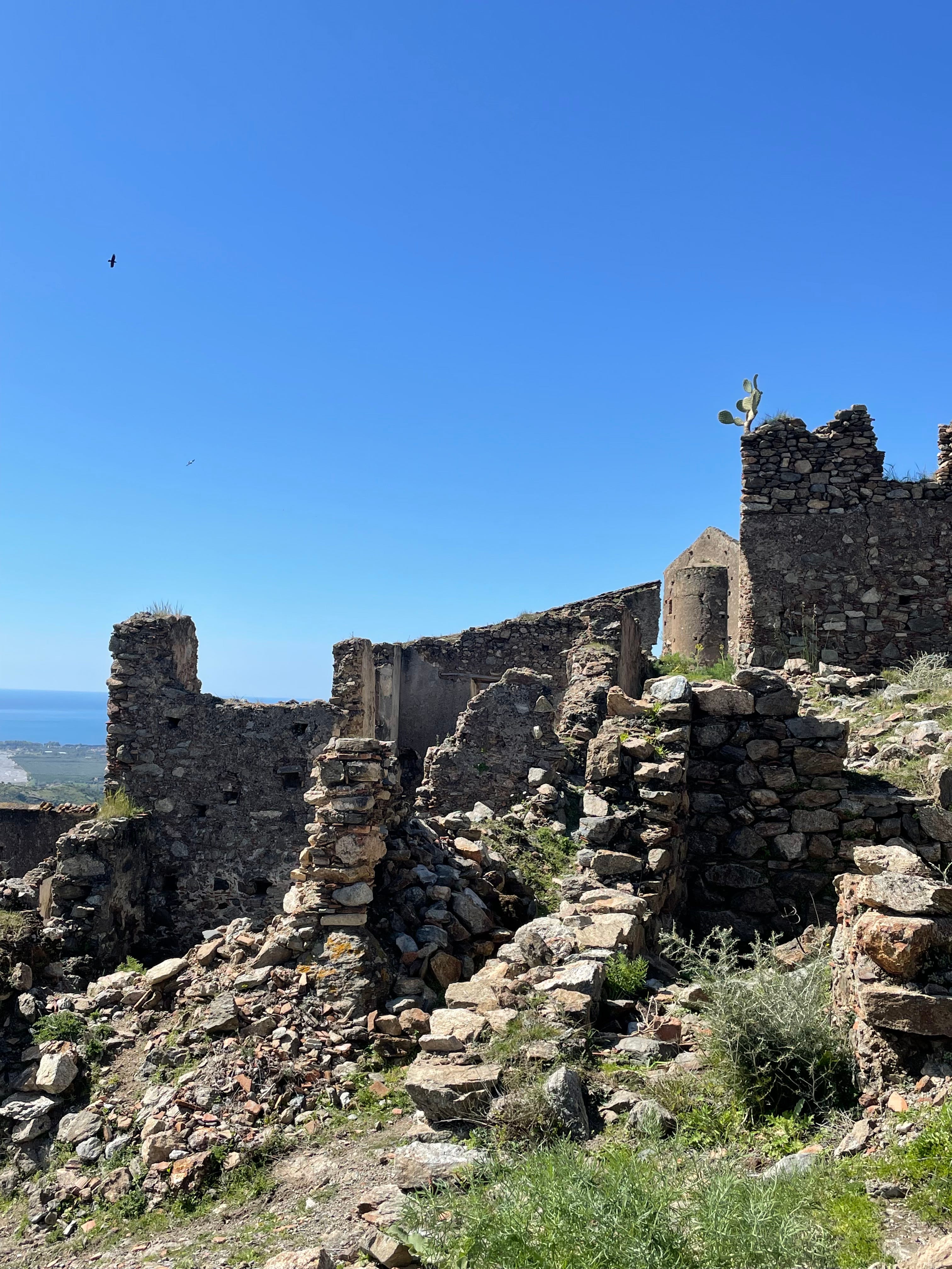
After saying goodbye to Ugo's donkey, Pasquale, we joined a friend of mine from Bova for Leg 3 - a purely uphill stretch of the trail that takes you from the Amendolea's riverbed up to Bova. This was another diversion since the suggested route wasn't possible: it had rained too much in previous weeks to cross the Amendolea on foot to then climb up to Gallicianò, back down to the riverbed and up to Bova along the trail. Our route was approximately 7km and a 700m climb while the suggest route is 14km and a 1200m climb. We stopped off at the Castello Ruffo and Amendolea Vecchia—Old Amendolea—a ruined town that clings onto the almost vertical mountainside. Amendolea Vecchia dates back to the 12th century when people took refuge from invasions from the sea. Its final inhabitants left after a flood in 1953.
Amendolea Vecchia was followed by a bit of an uphill slog to Bova but we couldn't complain about the views. Baby goats playing on their barn roof offered us the perfect excuse to take another break before the final push but we were rewarded with lestopitte once we arrived. These are a local speciality – thin, fried disks of dough which Mimmo then fills with all sorts of mouth-watering options like parmigiana di melanzane and fennel sausages.


Bova – Brigha – Bova. Leg 4.
We free-styled the next day after the creamiest cappuccino in the bar in Bova's square. The suggested route for Day 4 is a circular hike into the mountains to visit various rock formations and religious sites but we chose to walk to the hillside of Brigha which runs away from Bova, stretching down to the Ionian Sea with views over to Etna in the distance. I already knew Brigha and many of its inhabitants. Here a couple from Rome have recently planted a new vineyard, an English couple have an olive grove, and a local family of herders make sheep and goats cheese. And this is where we headed that morning, to watch milk being turned first into cheese and then ricotta. We explored Bova in the afternoon and returned to the Cooperativa San Leo for our second feast. The first night we ate maccheroni with mutton ragu, then chunks of slow-cooked mutton and sautéed brassicas. The second night we gorged on maccheroni with pork ragu, then pork sausages, sautéed broad beans picked that morning and salad.


Bova – Palizzi. Leg 5.
With Bova now behind us we walked down the steep hillside and across La Valle dei Mulini – the Valley of the Mills. This area was once covered in wheat fields – the ruins of seven mills lie along the riverbank. Once harvested, farmers would lay out the wheat over a small flat area above the river. They would use the breeze that rushed up the valley from the sea around 9:00 each morning to separate the wheat from the chaff. We stopped off for an 11:00am beer with a goatherder who recognised us. Light-headed and wobbly legged, we pushed on up to reach the ridge that runs down to the sea between Bova and Palizzi. Here olive and citrus groves gave way to broom, wild olive bushes and Euphorbia before we reached the vineyards outside Palizzi. Wine from Palizzi is recognised with an IGT (Indicazione Geografica Tipica). Local grape varieties include Nerello Mascalese, Gaglioppo, Greco Bianco and Nocera. On the approach to Palizzi we passed the impressive 14th century castle built atop a huge rock beneath which lies the knot of narrow streets and tiny courtyards that make up the town. The view from our beds looked straight out across the rooftops and over to the woodland beyond.


Palizzi – Pietrapennata – Staiti. Leg 6.
After a breakfast of many sweet treats we crossed the river and headed up and away from Palizzi but kept stopping to take in the view back down to the town. We climbed up through old woodland and then met the road which took us to the small village of Pietrapennata. From a walk around it appeared only a couple of houses were still inhabited though neat rows of salad and vegetables were growing in small plots between the houses. We wound our way from Pietrapennata, past a notoriously angry donkey (behind a fence), and across a valley where the ruins of the Byzantine Church of the Madonna of Alica and monastery lie. I took my one and only tumble of the hike in the religious rubble (divine intervention?) – it turns out a French walker had done the same not long before and had to be carried away off the mountain. We made our final ascent to the top of Monte Cerasia, the highest point of the hike, and enjoyed the phenomenal views right up the Ionion coast beyond Siderno, across the mountains, and back over to Bova, Pentedatillo and Sicily on the horizon. We were already talking about our next hike as we headed down towards Staiti where our host presented us with certificates before a final feast cooked by his sister.


In short
Hike high points: lush Barone, steaming bowls of maccheroni and waking up each morning knowing I was going to be hiking all day beside my sister.
Hike low points: lying in the monastery rubble, a creaky knee and trying to climb a wet clay hillside.
Would 100% recommend. If you're thinking of doing the hike and want to find out more, please get in touch!